
Bariloche · Circuito Chico · Cerro Campanario · Isla Victoria · Arrayanes Forest · Cerro Tronador · Seven Lakes Route · Villa La Angostura · San Martín de los Andes · 12 min read
Bariloche 7 Day Itinerary: Circuito Chico, Tronador and the Seven Lakes by Car
7 days · 7 cities
Duration
7 days
Estimated budget
1.4 to 2.3 million pesos, excl. flights
Best time to go
December to March; July and August for snow
Visa
Visa free for EU, US and Canada, 90 days
This Bariloche 7 day itinerary uses a rental car, the easiest way to do the Seven Lakes and Tronador. Two bases: four nights in Bariloche and two in San Martín de los Andes, at the end of the Seven Lakes Route.
In short: the town and Circuito Chico, Cerro Otto and Isla Victoria by boat, a day at Cerro Tronador, the Seven Lakes and Valle Encantado. Entry rules, costs and food are at the end.
Day 1: arrival in Bariloche, from the Centro Cívico to the cathedral
Centro Cívico: the stone and timber square by the lake

About an hour, free. Pick up the car at the airport, east of town, drop your bags at the hotel and start at the main square. The Centro Cívico is a group of alpine style stone and timber buildings from the 1940s facing Lake Nahuel Huapi, and the town radiates out from it.
One of the buildings houses the Patagonia Museum. Calle Mitre, which runs east from the square, is lined with chocolate shops, and it is where almost everyone makes their first purchase.
Bariloche Cathedral: the neo-Gothic tower above the waterfront

Quick stop, 30 minutes, free, a ten minute walk from the Centro Cívico along the waterfront. The Catedral Nuestra Señora del Nahuel Huapi is built of stone in neo-Gothic style, and its tower appears in nearly every photo of the town.
Go in for the stained glass and leave on the lake side: sunset over Nahuel Huapi from the cathedral lawn is a good way to end your arrival day.
Day 2: Circuito Chico, from Cerro Campanario to Colonia Suiza
Cerro Campanario: the 360 degree view over the lakes

About 1h15, 30,000 pesos for the return chairlift, 15,000 for children aged 5 to 12; it runs from 9am to 5pm, the time of the last ride up. It sits at km 17.5 of Avenida Bustillo, the road that follows the lake west, and it is the first stop on the Circuito Chico.
From the top you see Nahuel Huapi, Lake Perito Moreno, the Llao Llao peninsula and the islands in a full circle. There is a café at the summit, and breakfast with that view is the reason to go up early.
Llao Llao Hotel and Puerto Pañuelo: the postcard of the peninsula

Quick stop, 30 minutes, free, at km 25. The timber and stone hotel was designed by the architect Alejandro Bustillo and stands on a hill between two lakes.
Below it is Puerto Pañuelo, where the Day 3 boat leaves from. Just above the road, the Capilla San Eduardo, a wooden chapel overlooking the harbour, is worth the five minute climb.
Punto Panorámico: the most photographed viewpoint on the Circuito Chico

Quick stop, 30 minutes, free. After the hotel, the road skirts Bahía López and climbs to this roadside viewpoint.
From here you look down on Lake Perito Moreno, the Llao Llao peninsula and the hotel, the shot on half the postcards in town.
Colonia Suiza: curanto on Wednesdays and Sundays
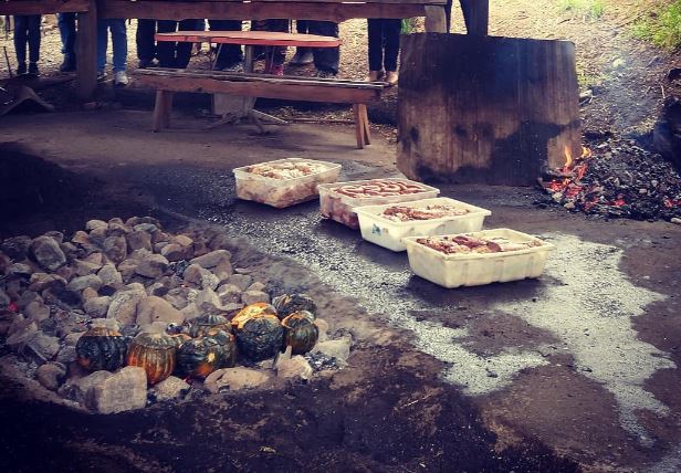
About two hours, and it is lunch. The village was founded by Swiss immigrants in the late 19th century at the foot of Cerro López, a short detour off the Circuito Chico. On Wednesdays and Sundays, all year round, there is a craft fair and curanto, served around 2pm.
Curanto is pork, chicken, sausage, potatoes and pumpkin cooked on red hot stones in a pit in the ground, covered with leaves and earth for hours. If your Day 2 is not a Wednesday or a Sunday, swap it with Day 3: without the curanto, the detour is hard to justify.
Day 3: Cerro Otto and the boat to the Arrayanes Forest and Isla Victoria
Cerro Otto: the cable car and the revolving café

About 2h30, 60,000 pesos for adults and 30,000 for children aged 6 to 12 and over 65s, including the return cable car. It opens at 10am, sits at km 5 of Avenida de los Pioneros and has a free bus from the centre and free parking.
The cabins take 12 minutes to reach 1,405 metres. At the top, the café turns slowly to show Nahuel Huapi, the town and the Andes in a full circle, and there is a gallery of replicas of Michelangelo sculptures. The cable car stops in strong wind, so check the complex’s social media before you go.
Arrayanes Forest: the cinnamon trees of Quetrihué

The whole afternoon by boat, from Puerto Pañuelo, 25 km from the centre. Turisur and Cau Cau leave around 2pm and return at 6.30pm, for 140,000 pesos; at Puerto Pañuelo you pay separately a 7,600 boarding fee and 35,000 for Nahuel Huapi National Park. Arrive an hour early.
The boat stops for 45 minutes at the tip of the Quetrihué peninsula, in a forest of arrayanes, cinnamon barked trees with white flowers that rarely grow into a forest like this. A wooden boardwalk loops between the trunks, and Los Arrayanes National Park was created to protect it.
Isla Victoria: Puerto Anchorena and Playa del Toro

About an hour on the half day trip, or 2h30 on the full day departure, which leaves at 12.15pm and replaces Cerro Otto. Isla Victoria is the largest island in Nahuel Huapi, and the boat lands at Puerto Anchorena.
Short trails lead through the forest, and the visit ends at Playa del Toro, a volcanic sand beach with rock paintings by the region’s Indigenous peoples.
Day 4: Cerro Tronador, Pampa Linda and the Ventisquero Negro
Lake Gutiérrez: the first stop on the way to Tronador

Quick stop, 30 minutes, free, beside Ruta 40 south of town. Leave Bariloche around 8.30am: the road to Tronador has set hours for driving up, and it pays to arrive with time to spare.
Los Coihues is the best known beach on the lake, with calm water, and it is where you can rent a stand up paddleboard in summer. Stop for the photo and carry on south along the shore.
Pampa Linda: Tronador from the meadow

About an hour, with lunch. Follow Ruta 40 to Lake Mascardi and turn onto the Tronador road; at the entrance, Nahuel Huapi National Park charges 35,000 pesos per person. From Los Rápidos there are about 50 km of gravel with one way traffic: you can only drive up from 10.30am to 2pm and only down from 4pm to 6pm. It is about two hours from Bariloche.
Pampa Linda is a clearing at the foot of Cerro Tronador, an extinct volcano on the Chilean border covered in glaciers. The lodge serves lunch and the trails to the glaciers start here. The mountain is named after the thunder of falling ice, so listen for it.
Ventisquero Negro: the black glacier that ends in a lagoon

About two hours, until it is time to head down. At the end of the road, a few kilometres past Pampa Linda, the Ventisquero Negro ends in a green lagoon full of ice blocks. It is dark because it carries rock and sediment down from Tronador.
From the same car park a trail leads to the Garganta del Diablo, a wall of waterfalls beneath the glacier. Start down at 4pm, when the return window opens, and you will be back in Bariloche for dinner. In winter the road may require a high clearance vehicle and chains; check the park website.
Day 5: the Seven Lakes Route to San Martín de los Andes
Río Correntoso: the tiny river of Villa La Angostura

Quick stop, 20 minutes, free. Bariloche to Villa La Angostura is about 1h15 along the north shore of Nahuel Huapi. Fill up the tank in town before heading onto the route.
On the way out of the village the road crosses the Río Correntoso, which links Lake Correntoso to Nahuel Huapi in a few hundred metres of blue water. Walk down beside the bridge: it is one of the most popular trout fishing spots in the region.
Lago Espejo: the first of the seven lakes

Quick stop, 30 minutes, free. The Seven Lakes Route is the fully paved stretch of Ruta 40 between Villa La Angostura and San Martín de los Andes, past lakes Espejo, Correntoso, Villarino, Falkner, Escondido, Machónico and Lácar.
Espejo, which means mirror, comes first. It is named for still water that reflects the forest, and the viewpoints are right by the road.
Lake Falkner: the beach halfway along the route

About an hour, free, and the longest stop of the day. After Villarino the road runs right beside Falkner, with a sandy beach facing Cerro Buque, the flat topped mountain whose name means ship.
In summer you can swim, in cold water. Nearby, the Vuliñanco waterfall drops a few metres from the road. From Falkner it is about an hour more to San Martín de los Andes, past Escondido and Machónico.
Mirador Arrayán: San Martín de los Andes from above

About 45 minutes, free, late in the afternoon after checking in. The viewpoint is on the hillside a few minutes’ drive from the centre and looks over the bay of Lake Lácar, with the town tucked at the end of the valley.
San Martín de los Andes is smaller and quieter than Bariloche, with low timber houses and a lakeside promenade. Head down for dinner in the centre, a few blocks from the pier.
Day 6: San Martín de los Andes, from Mirador Bandurrias to Quila Quina
Mirador Bandurrias: Lake Lácar on Mapuche land

About 1h30, 10,000 pesos per person, charged by the Mapuche Curruhuinca community, which owns the land. It is 5 km from the centre: by car along Ruta 48 towards Hua Hum, or on foot, a trail of about an hour that starts at the end of Juez del Valle street.
The viewpoint is a rocky outcrop above Lácar at 800 metres, with the whole lake stretching west and the town on the other side. Go in the morning and come back in time for the boat.
Quila Quina: the Lácar beach by catamaran

The whole afternoon. The Naviera Lácar y Nonthué catamaran leaves from the pier on the waterfront and takes 30 minutes, for 70,000 pesos return; the 2026 timetable leaves at 10am, 12pm, 1pm and 4pm and returns at 11.15am, 1.30pm, 3.15pm and 6pm. Lanín National Park entry is charged separately.
Quila Quina is a village with a pebble beach on the south shore of the lake, inside the park and on Mapuche land. Beyond the beach, a trail leads to the Arroyo Grande waterfall, with a 5,000 peso fee. Take the 1pm boat and return on the 6pm.
Day 7: the drive back through Junín de los Andes and Valle Encantado
Vía Christi: the sculptures on Cerro de la Cruz in Junín

Quick stop, 45 minutes. The drive back to Bariloche via Junín de los Andes and Valle Encantado is fully paved and longer, about 3h30 at the wheel, but it does not repeat the Seven Lakes. Junín is 40 km north of San Martín.
Vía Christi is a sculpture park on Cerro de la Cruz, at the edge of town: a Way of the Cross in sculpture along a trail that climbs the hill, with views over the valley and the Chimehuín River.
Valle Encantado: the rock towers of the Limay River

About 45 minutes, free, on Ruta 237, around an hour from Bariloche. The road follows the Limay River valley between towers of volcanic rock whose shapes have earned names, the most famous being the Dedo de Dios, a lone spire on the slope.
There are viewpoints with parking beside the road. From here Bariloche airport is on the way, before the town, so you can return the car and catch an evening flight.
Do you need a visa for Argentina?
Not for most visitors. Citizens of the European Union, the United States and Canada, among many other countries, enter Argentina visa free as tourists for up to 90 days with a passport. Citizens of Mercosur countries and associated states can also enter with their national identity card. Check your own nationality with the Argentine consulate before you book.
Since Decree 366 of 2025, Argentina provides for requiring health cover from foreign tourists: travel with insurance that covers medical expenses and carry the policy.
Can you drive in Argentina with a foreign licence?
Yes. Licences from Mercosur countries are valid on their own for tourist trips. Visitors from elsewhere should carry an International Driving Permit alongside their national licence, which Argentina recognises under the Geneva and Vienna conventions, together with their passport. Rental companies ask for the licence and a credit card; ask whether the contract covers gravel roads, because the Tronador road is unpaved.
Car or tours? A compact car averages 45 to 90 US dollars a day. Scheduled tours charge 96,000 pesos for Tronador, including park entry, and 114,000 for a Seven Lakes day trip of more than 10 hours with two hours in San Martín. For two people the car costs less than the tours combined, and it is what lets you sleep in San Martín de los Andes instead of driving back the same day.
When is the best time to visit Bariloche?
December to March for this itinerary. It is lake season: the boats run daily, the Tronador road is open to ordinary cars and you can swim at Falkner and Quila Quina. January is the busiest and most expensive month.
July and August are the snow season, with Cerro Catedral open for skiing. At that time the Tronador road may require a high clearance vehicle and chains, and the Seven Lakes Route may need chains too, so swap Day 4 for a day at Cerro Catedral. In October the town holds Bariloche a la Carta, its food week, from 5 to 12 October in 2026.
How to get to Bariloche and get around
Most international travellers fly into Buenos Aires and connect to Bariloche on a domestic flight of around two hours. In the southern winter there are also seasonal direct flights from São Paulo. The airport is east of town, and the rental companies hand over cars there.
Carry Argentine pesos in cash: the national park fees at Puerto Pañuelo, Mirador Bandurrias and the stops on the Tronador road, where the mobile signal drops out, are easier that way.
Where to eat in Bariloche: curanto, lamb and chocolate
The food here is about fire and lakes: meat roasted slowly, trout from Patagonian rivers, red berries and craft beer, which Bariloche brews in quantity. The most useful advice is about the calendar: the Colonia Suiza curanto only happens on Wednesdays and Sundays, so plan Day 2 around it.
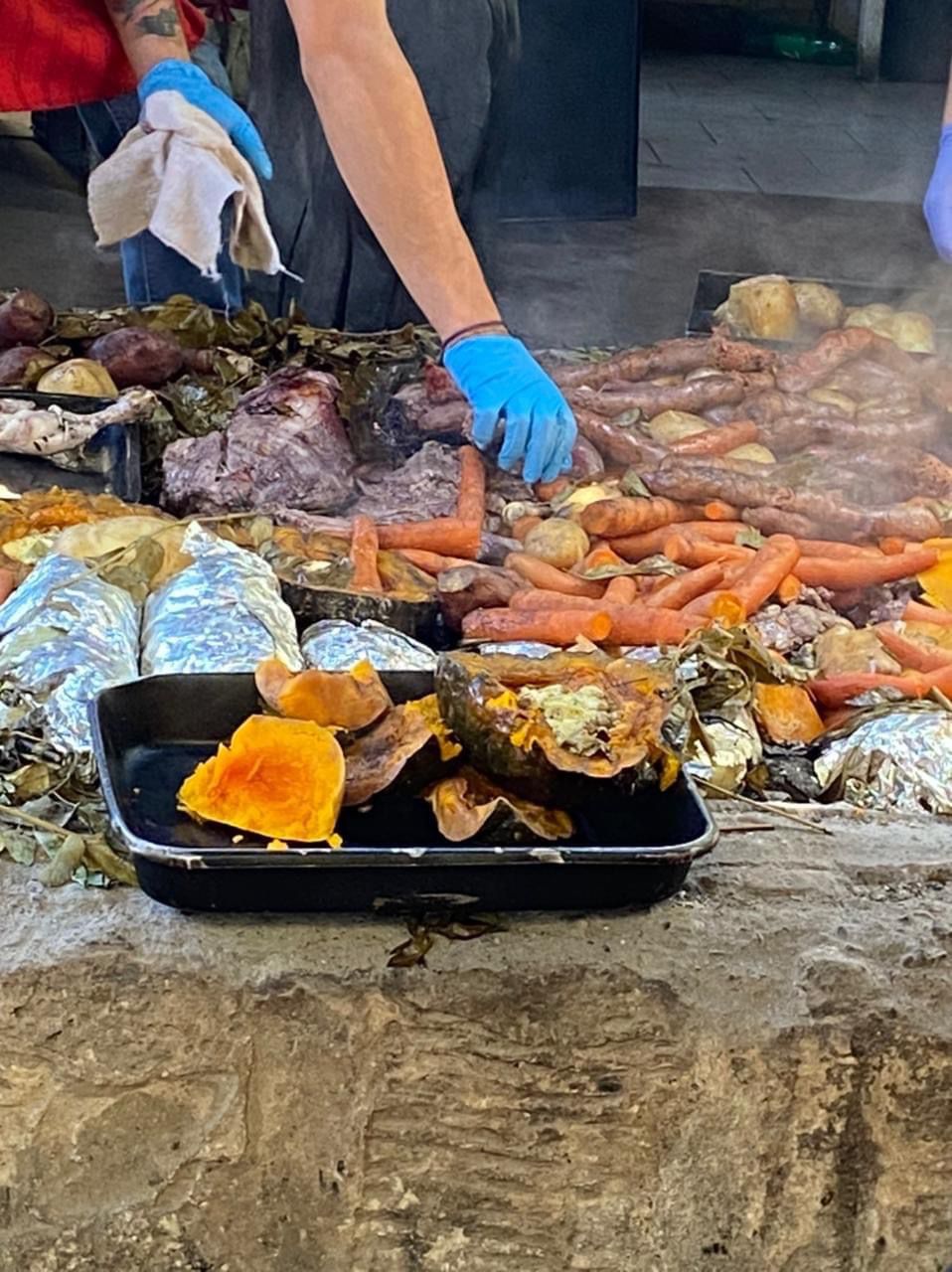
Curanto is cooking on red hot stones in a pit covered with leaves and earth: pork, chicken, sausage, potatoes and pumpkin come out together, tasting of smoke. In Colonia Suiza it is served around 2pm.

Patagonian lamb is the dish of the region’s grills: the whole animal, splayed on an iron cross, roasts for hours beside the wood fire without touching the embers. Order it in San Martín de los Andes or in Bariloche.

Chocolate is the essential souvenir. The shops cluster on Calle Mitre, and chocolate en rama, thin rolled flakes, is the house style. At Easter the town builds a giant chocolate egg in the centre, like the one in the photo. To drink, order a local craft beer, and for dessert anything with the region’s red berries.
Is 7 days enough for Bariloche?
It is enough for the essentials of Bariloche and the Seven Lakes without rushing: the Circuito Chico, Cerro Otto, the boat to the Arrayanes Forest and Isla Victoria, a full day at Tronador and two nights in San Martín de los Andes. It is what Lonely Planet called Bariloche and the lakes when it put the region in Best in Travel 2027.
What was left out and deserves more days: Cerro Catedral, which has lifts and trails in summer; the boat to Puerto Blest and the Los Cántaros waterfall; El Bolsón and Lake Puelo, two hours south; and the mountain hut hikes, such as the one to Refugio Frey.
For southern Patagonia, continue with our 6 day itinerary for Ushuaia and El Calafate, and if you pass through the capital there is our 5 day Buenos Aires itinerary. Save this itinerary on Galmund to fit the days to your calendar.
Estimated budget per person
Prices checked on 24 September 2026. Check current prices at Aerosilla del Cerro Campanario, tarifas e horários · Teleférico Cerro Otto, tarifas e horários · Cau Cau, barco para a Isla Victoria e o Bosque de Arrayanes · Parque Nacional Nahuel Huapi, tarifas de ingresso · Parque Nacional Nahuel Huapi, horários do caminho ao Tronador · Naviera Lácar y Nonthué, catamarã para Quila Quina · Parques Nacionales da Argentina, tarifas de acesso · Migraciones, documentos de viagem do Mercosul · Governo argentino, carteiras de motorista do Mercosul e estrangeiras.
Frequently asked questions
How much does a 7 day trip to Bariloche cost?+
Between 1.4 and 2.3 million Argentine pesos per person, excluding flights, roughly 900 to 1,500 US dollars. That covers six nights in a mid range hotel in a double room, food, the rental car shared by two with fuel, and entry fees. Entry fees add up to 420,000 to 480,000 pesos: the Isla Victoria boat costs 140,000, plus a 7,600 boarding fee and 35,000 for the national park; Cerro Otto 60,000; Cerro Campanario 30,000; and the Quila Quina catamaran 70,000.
Do you need a car for the Seven Lakes Route?+
It is not essential, but it helps. There is a day tour from Bariloche for about 114,000 pesos, lasting more than 10 hours with two free hours in San Martín de los Andes. By car, Ruta 40 is fully paved between Villa La Angostura and San Martín, you can stop at every lake and sleep in San Martín, which is what this itinerary does. In winter the road may require chains.
What are the opening hours of the road to Cerro Tronador?+
The gravel road from Los Rápidos is one way for most of the day. You can only drive up from 10.30am to 2pm and only down from 4pm to 6pm, with two way traffic from 7.30pm to 9am. Driving up between 2pm and 7.30pm is prohibited. It takes about two hours from Bariloche to Pampa Linda, and at the Lake Mascardi entrance the national park charges 35,000 pesos per person. In winter the road may require a high clearance vehicle and chains.
Which days is curanto served in Colonia Suiza?+
Wednesdays and Sundays, all year round, together with the village craft fair. Preparation starts late in the morning and the curanto is usually served around 2pm. Colonia Suiza is about 25 km from central Bariloche, a short detour from the Circuito Chico, so it is worth planning the circuit day for a Wednesday or a Sunday.
Can you visit Bariloche in winter?+
Yes, but the plan changes. July and August are ski season at Cerro Catedral, the boats to Isla Victoria run all year and the Cerro Otto cable car opens in winter too. The Tronador road may require a high clearance vehicle and chains, and the Seven Lakes Route may need chains, so in winter it is best to replace the Tronador day with Cerro Catedral and check road conditions before driving north.
Ready to go?
Save this itinerary to your Galmund and take the schedule, map and budget with you. Edit, share and track it all on the globe.
Save this itinerary to my GalmundBeen there already?
Pin this trip on your globe and keep your photos where they were taken.
Pin it on my globe